Aquí un estudio sobre el tema (en inglés)
http://www.siagua.org/sites/default/files/documentos/documentos/bolivia.pdf
Este es el que había confundido con "libro" la semana pasada, no tenía tiempo de buscarlo en ese momento, ahora lo encontré leyendo las referencias de Wikipedia.
Algunas citas y un resumen de lo que dice, para los que no hablan inglés.
Preliminary evidence supports claims that the groundwater was principally recharged by glacial melt water, thousands of years ago (SERGEOTECMIN, 2003). The Silala Aquifer is considered a transboundary aquifer, but little is known about the underground flow component
El agua subterranea parece venir de glaciares, la importancia es que se refuerza que no es lluvia sino manantiales y esto me parece fortalece la posición Boliviana.
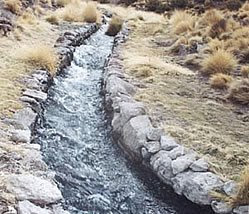
Most of the springs are drained by a series of small, man-made channels which direct the flow towards two central drainage channels, the north and south canals, which join to form a principal canal (Fig. 2). Each canal is clearly man-made (lined with rocks and very straight in certain stretches; Fig. 2). The south canal is nearly 3 km long and contributes about two thirds of the flow to the principal canal, whereas the north canal is less than 1 km long and contributes the remaining third of the flow. The principle canal directs the water for about 700 m before crossing the international border into the II Antofagasta Region, Chile.
La mayoría de las fuentes de agua son llevadas por pequeños canales, hechos por el hombre (apoyaría posición Boliviana)
Geological, topographical, and historical evidence suggests that the Silala springs flowed overland from Bolivia to Chile prior to the canalization. The principal canal clearly follows a natural drainage course featuring significant, natural alluvial erosion, including a relatively deep (tens of metres) canyon incised in the desert floor
Efectivamente la evidencia parece sugerir que a pesar de lo anterior, el flujo de agua actual es anterior a la canalización (lo que dice Lenwe).
Aquí viene el tremendo fail Boliviano:
The general manager of the Bolivian company hired (in 2009) to evaluate Silala’s hydroelectric potential concluded, based on detailed topographic studies, that the canals were constructed to make more efficient, but not to alter, the natural course of the waters, which naturally and inexorably flow to Chile (Alvarez, 2010). In the 1908 application for the concession to use the waters of Silala, a Bolivian citizen acting on behalf of the Antofagasta (Chili) & Bolivia Railway Co. Ltd. (FCAB, following the Spanish acronym), stated that “In the Province of Sud Lípez near the border, there exist springs which form the Siloli River, which flows in Chilean territory” (Martínez, 2004).
Aquí hay dos cosas demoledoras en mi opinión para la posición Boliviana.
1. Existiría un estudio realizado por Bolivia para evaluar el potencial hidroelectrico del Silala, que habría indicado que los canales fueron realizados para hacer eficiente, pero no para alterar el curso de agua natural.
2. La concesión de 1908, indicaría en el texto que existe el rio, por lo cual no se puede argumentar que se "creo" a raíz de dicha concesión.
Combo braker!!! y cago Bolivia.
En resumen, parece ser que la canalización en el sector Boliviano es real, pero se mantiene el punto indicado anteriormente a que a pesar de hecho el curso del río es anterior.


 (si es que fueses chileno
  ). Pero en fin, se sabía que los cholos le estaban haciendo el quite a los estudios por lo mismo, no hayan con que darnos los re culiaos